
Heavy snowfall late last week kept public safety personnel busy, but not overwhelmed, officials said.
A National Weather Service spokesman said parts of Forsyth County received as much as 3 inches of snow Friday.
Forsyth County Fire Capt. Jason Shivers said the most serious wreck happened as the snow began to fall about midday.
Authorities responded to a three-vehicle wreck that included a Sawnee EMC truck on Hwy. 20 and Sanders Road. Four people suffered minor injuries in the collision.
Shivers said the afternoon was fairly busy, with minor vehicle wrecks and reports of trees and limbs falling.
Sheriff’s Capt. Frank Huggins said deputies worked dozens of wrecks, several of which involved minor injuries.
Authorities also received numerous calls for assistance from motorists who had slid off icy roads.
Shivers said the county’s emergency operations center was staffed with representatives from the sheriff’s office, fire department and 911 well into Friday night.
Officials continued to monitor the weather throughout the day Saturday.
Though the snowfall stopped Saturday, motorists still had to contend with icy patches.
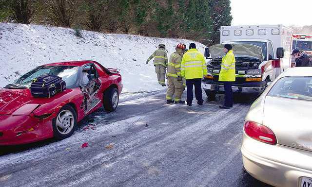
In fact, an ambulance responding to a two-vehicle wreck in the Polo Fields subdivision slid into one of the vehicles.
Shivers said the ambulance was traveling at a low speed and slid on ice as it approached the scene.
No one was injured as a result of the collision or the initial wreck. The ambulance was slightly damaged.
“It was just an unfortunate case of an emergency vehicle coming to the same fate that many civilian vehicles do,” Shivers said. “The ice was unavoidable.”
He said officials began monitoring the weather again Sunday night, due to the potential of a second round of snowfall Monday morning.
Instead, however, residents awoke to just a chilly rain.
Now, for the first time in what may seem like weeks, sunny days are ahead.
The National Weather Service forecast calls for mostly sunny skies today through Friday.
A break from wintry precipitation may be welcome news to many in the area.
January saw 6.1 inches of precipitation, according to data from the National Weather Service, with February totaling about 3.5 inches so far.
Those numbers are near average for winter.
Three inches of snow in February is not normal, however, as the average snowfall for the month is 0.4 inches. The average snowfall for January is 1.1 inches.
A threat of snow and ice has become a near weekly occurrence for North Georgia, but for at least a few days the sun will shine and it may even warm up by the end of the week.
Temperatures are expected to hit 43 today, 49 on Thursday and 54 on Friday. The average high for February is 43.
By Friday night, though, there’s that now familiar slight chance of snow.
FCN regional staff contributed to this report.
A National Weather Service spokesman said parts of Forsyth County received as much as 3 inches of snow Friday.
Forsyth County Fire Capt. Jason Shivers said the most serious wreck happened as the snow began to fall about midday.
Authorities responded to a three-vehicle wreck that included a Sawnee EMC truck on Hwy. 20 and Sanders Road. Four people suffered minor injuries in the collision.
Shivers said the afternoon was fairly busy, with minor vehicle wrecks and reports of trees and limbs falling.
Sheriff’s Capt. Frank Huggins said deputies worked dozens of wrecks, several of which involved minor injuries.
Authorities also received numerous calls for assistance from motorists who had slid off icy roads.
Shivers said the county’s emergency operations center was staffed with representatives from the sheriff’s office, fire department and 911 well into Friday night.
Officials continued to monitor the weather throughout the day Saturday.
Though the snowfall stopped Saturday, motorists still had to contend with icy patches.
In fact, an ambulance responding to a two-vehicle wreck in the Polo Fields subdivision slid into one of the vehicles.
Shivers said the ambulance was traveling at a low speed and slid on ice as it approached the scene.
No one was injured as a result of the collision or the initial wreck. The ambulance was slightly damaged.
“It was just an unfortunate case of an emergency vehicle coming to the same fate that many civilian vehicles do,” Shivers said. “The ice was unavoidable.”
He said officials began monitoring the weather again Sunday night, due to the potential of a second round of snowfall Monday morning.
Instead, however, residents awoke to just a chilly rain.
Now, for the first time in what may seem like weeks, sunny days are ahead.
The National Weather Service forecast calls for mostly sunny skies today through Friday.
A break from wintry precipitation may be welcome news to many in the area.
January saw 6.1 inches of precipitation, according to data from the National Weather Service, with February totaling about 3.5 inches so far.
Those numbers are near average for winter.
Three inches of snow in February is not normal, however, as the average snowfall for the month is 0.4 inches. The average snowfall for January is 1.1 inches.
A threat of snow and ice has become a near weekly occurrence for North Georgia, but for at least a few days the sun will shine and it may even warm up by the end of the week.
Temperatures are expected to hit 43 today, 49 on Thursday and 54 on Friday. The average high for February is 43.
By Friday night, though, there’s that now familiar slight chance of snow.
FCN regional staff contributed to this report.