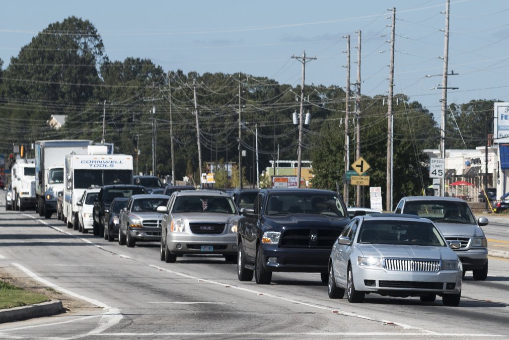
Hall County can proceed with four transportation studies — including one examining Dawsonville Highway-McEver Road traffic flow — now that it has been approved for $520,000 in federal road planning money.
The studies involve a potential road connector system involving Dawsonville Highway and McEver Road, pedestrian/bicycling trail connections in Gainesville and South Hall, and Oakwood traffic improvements.
Several steps lie ahead before the efforts begin, with the Hall County Board of Commissioners’ approval of consultants set for Dec. 14, said Sam Baker, transportation planning manager with the Gainesville-Hall Metropolitan Planning Organization.
The MPO is the Hall area’s lead transportation planning agency.
The plan is to finish the studies by June 30, he added.
Contracts with the Georgia Department of Transportation “give us until the end of 2018 to complete the studies,” Baker said.
However, “we want to complete them sooner so that the local governments have some study results to share with the public if they choose to pursue a transportation special purpose local option sales tax next fall.”
The Dawsonville Highway/McEver Road study could have the largest impact, as that area is experiencing ever-increasing traffic congestion.
The study will focus on traffic flow through the heavily commercialized intersection but also potential connections between Dawsonville Highway and McEver.
The area’s traffic congestion has been the subject of much public interest this year, especially with the Gainesville City Council’s consideration — and eventual approval — of an 860-home older-adult community off Dawsonville Highway and Ahaluna Drive.
Several steps are being taken to address traffic, including DOT plans to change the intersection on McEver at entrances to Village Shoppes at Gainesville and McEver Corners shopping centers.
In a project that could wrap up by Black Friday, motorists will no longer be able to turn left out of Village Shoppes to head south on McEver or turn left into the shopping center heading south from Dawsonville Highway.
Also, through a series of concrete median fixes, McEver Corners shoppers won’t be able to turn left to head north on Dawsonville Highway.
Gainesville plans to use live video to keep an eye on intersections along the Ga. 53 corridor in the McEver Road area and make immediate signal timing changes as needed, public works director Chris Rotalsky has said.
The two trail studies focus on efforts by several governments to expand existing systems running from Gainesville to Friendship Road/Ga. 347 in South Hall.
On the northern end, Gainesville wants to connect its Midtown Greenway to Hall County’s Highlands to Islands Trail.
The Midtown Greenway ends at Martin Luther King Jr. Boulevard east of Queen City Parkway/Ga. 60. And Highlands to Islands Trail’s Chicopee Section ends at Palmour Drive west of the parkway.
And there’s a lot of developed property in between, including Lee Gilmer Memorial Airport.
Among other things, a study could show how the trail might intertwine with intersections between the two trails, such as Palmour Drive at Aviation Boulevard and Georgia Avenue at Industrial Boulevard.
In South Hall, the potential multi-use trail could run between Mundy Mill Road in Oakwood to Friendship Road near Flowery Branch and Buford.
The concept started about five years ago as officials learned that the widening of Ga. 347 would include a multi-use path and then later that the Spout Springs Road widening also would have such an amenity, City Manager Flowery Branch Bill Andrew has said.
The trail also would connect with Highlands to Islands.
“While Hall County, Flowery Branch and Oakwood are directly involved with this effort, we will have the ability to work with Gainesville and tie together several efforts into one common goal,” Andrew said in an email this week.
The Oakwood roads study will look particularly at potential intersection fixes, ranging from turning radius fixes to a roundabout at the post office on Main Street.
“There’s a number of different locations we think are worth us getting a study done to where we can get some conceptual-level layouts and some cost estimates,” City Manager Stan Brown has said.
All the studies have varying costs, with each one requiring a 20 percent funding match from the respective governments.
The Federal Highway Administration planning dollars trickle through the DOT to metropolitan planning organizations statewide.