
Good news for area hikers, cyclists and nature enthusiasts: Forsyth County officials plan to open part of a riverside trail winding more than seven miles along the southwest part of the county by the end of summer.
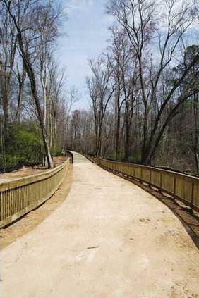
The first three phases of the Big Creek Greenway, a 12-foot wide multi-use concrete trail along Big Creek that will eventually span 15 miles beside the stream, are slated for completion in August 2009.
Once complete, the trail will be open to the public during daylight hours for residents to enjoy. A similar greenway or “linear park” runs through northern Fulton County along Big Creek as well.
Funding for the Big Creek Greenway comes from a $100 million parks, recreation and green space bond approved by voters last year, as well as impact fees collected from new development.
Initial construction of the trail at McFarland Road began in July 2008, and phase 2 and 3 construction started around the same time.
Upon completion of the first three phases, residents will be able to get on the trail at McFarland, Union Hill and Bethelview roads. Parking will also be available at these access points.
Throughout construction, some residents have voiced concern about water puddling up where the trail runs near Hwy. 9, near the end of Castleberry Road.
Forsyth County assistant director of engineering Tim Allen said residents may see some flooding on occasion along the trail, which he added has wooden boardwalks along some sections, due to its close proximity to the creek.
“Unfortunately, it may be underwater a couple times a year, segments may be under water for a day or so, but it should be a minor inconvenience if anything to use of the trail.”
Allen said the parks and recreation department will take over maintenance of the trail once the engineering department is finished. When flooding does occur, he said, department staff “will sweep it off and get it ready for use again.”
Phases 4 and 5 will stretch north from McGinnis Ferry Road to the Sawnee Mountain Preserve on Spot Road, totaling a 15-mile nature trail. Final construction of all five phases is scheduled for early 2011.
The board of commissioners approved the design of the two final phases at a board meeting last January. An award of $453,000 went to architects Pond & Co., who also designed the first three phases of the trail.
E-mail Frank Reddy at frankreddy@forsythnews.com.